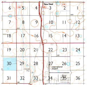
The one-mile-by-one-mile section occupies a seminal role in the settlement and land use of the American West. The survey system was established as a tool for the rapid sale of property to homesteaders and land speculators in the 19th century. The Homestead Act of 1862 alotted 640-acres to an individual who would make improvements on the land by building fences, a house, and other structures necessary for making the land productive. Section roads and their corrective shifts create a vast grid across the landscape of the Great Plains, forming the current basis for both township and rural settlement.
The site known as section 30 is located on the Southern High Plains, north of Lubbock and is a testing ground for studies conducted by thenorthroom on land subdivision, range management, farming, and the built environment. The proposal for section 30 addresses the intersection of agriculture, ecology, and urbanization to form a model for inhabiting a productive landscape.

Section 30
